


afur

adubarry
User
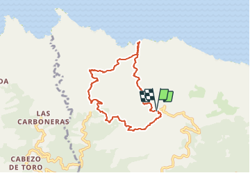

Length
9.7 km

Max alt
623 m

Uphill gradient
690 m
Km-Effort
18.9 km

Min alt
6 m

Downhill gradient
682 m
Boucle
Yes
Creation date :
2021-09-01 09:35:25.725
Updated on :
2021-09-01 19:39:47.659
6h04
Difficulty : Difficult

FREE GPS app for hiking
 SityTrail
IGN / Geographical institutes
SityTrail Plus
The world is yours!
About
Trail Walking of 9.7 km to be discovered at Canary Islands, Santa Cruz de Tenerife, Santa Cruz de Tenerife. This trail is proposed by adubarry.
Positioning
Country:
Spain
Region :
Canary Islands
Department/Province :
Santa Cruz de Tenerife
Municipality :
Santa Cruz de Tenerife
Location:
Anaga
Start:(Dec)
Start:(UTM)
377877 ; 3159371 (28R) N.
Comments